Answer 1:
Dammmmmmmn those be good questions!! That's
awesome!!
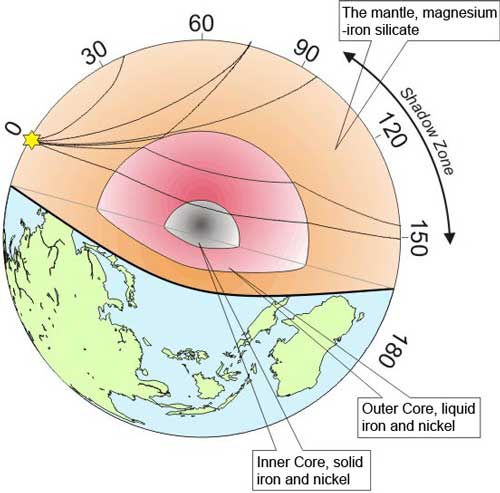
The easiest way to measure the thickness of
layers in the earth is by using Seismic waves --
these are sound waves that travel through the
earth. We use huge sounds at the surface of the
earth (sometimes dynamite for shallow layer
mapping, or you can use the sounds made by big
earthquakes to measure the layers through the
whole earth) and you track how long it takes for
the sound waves from the explosion to go through
the earth. The seismic waves will bounce back at
composition changes (where you have a change into
a different rock unit).
The speed of the seismic waves will change
depending on which rock layer it's traveling
through (the properties of each rock layer change
how fast sound travels in it). We can then
calculate how long the sound takes to travel
through each layer, and from that we calculate the
thickness of each layer. The amount of time also
tell us about the properties of each layer, and
this exact method is how we found out that the
outer core is liquid, but the inner core is solid!
As for the temperature inside the earth, we
calculate the innermost temperatures of the earth
from what we know about its composition. The inner
core is solid while the outer core is liquid, but
they have pretty much the same composition --
mostly iron. In the lab, we can simulate the
pressures inside the earth, and see how hot we
have to make it for solid iron to melt. That
should be the temperature at the boundary between
the outer core and the inner core.
As for the rest of the earth, mostly we make a
gradient from the temperature at the surface of
the earth, and it gets increasingly hotter as we
approach the core. We call this the geothermal
gradient and other than in places that are oddly
hot -- usually near volcanoes and such-- this
gradient does a pretty good job of estimating
temperature with depth in the earth.
Please look at the picture on the following link:
click
here to see
Click Here to return to the search form.
| 


